O&G lease proposal adds threats to Teton, Milk rivers
The Bureau of Land Management is proposing a record-high number of parcels to be opened up to oil and gas leases along the Hi-Line. The problem is that many sit along important waterways.
The Montana-Dakotas BLM office just released an environmental assessment of 87 federal parcels covering almost 18,000 acres from Cut Bank to Glasgow that could be leased to oil and gas development. None of the parcels previously had leases.
What that means is that private parties – individuals or companies – have expressed interest in these particular parcels so the BLM started the process.
The agency never reveals who initially makes the requests. But, it’s clear someone has a sudden large interest, although the reason is not clear when several companies are shutting down operations in the Bakken area because oil prices are so low. The interested parties originally nominated 101 parcels for leases, but the BLM deferred 14 parcels that lie within designated sage grouse core areas.
The Montana-Dakota BLM Region offers lease sales every quarter, but most of the sales have been in North Dakota. The largest Montana proposal over the past two years was in October 2014 when four Montana offices approved the lease of 25 parcels totaling almost 4.440 acres. Other than that, the Miles City Office has occasionally nominated a handful of parcels of a few hundred acres.
The BLM is asking for comments on the proposal for the next 30 days, and it’s likely that some will question the nearness of some parcels to the Milk and Teton rivers.
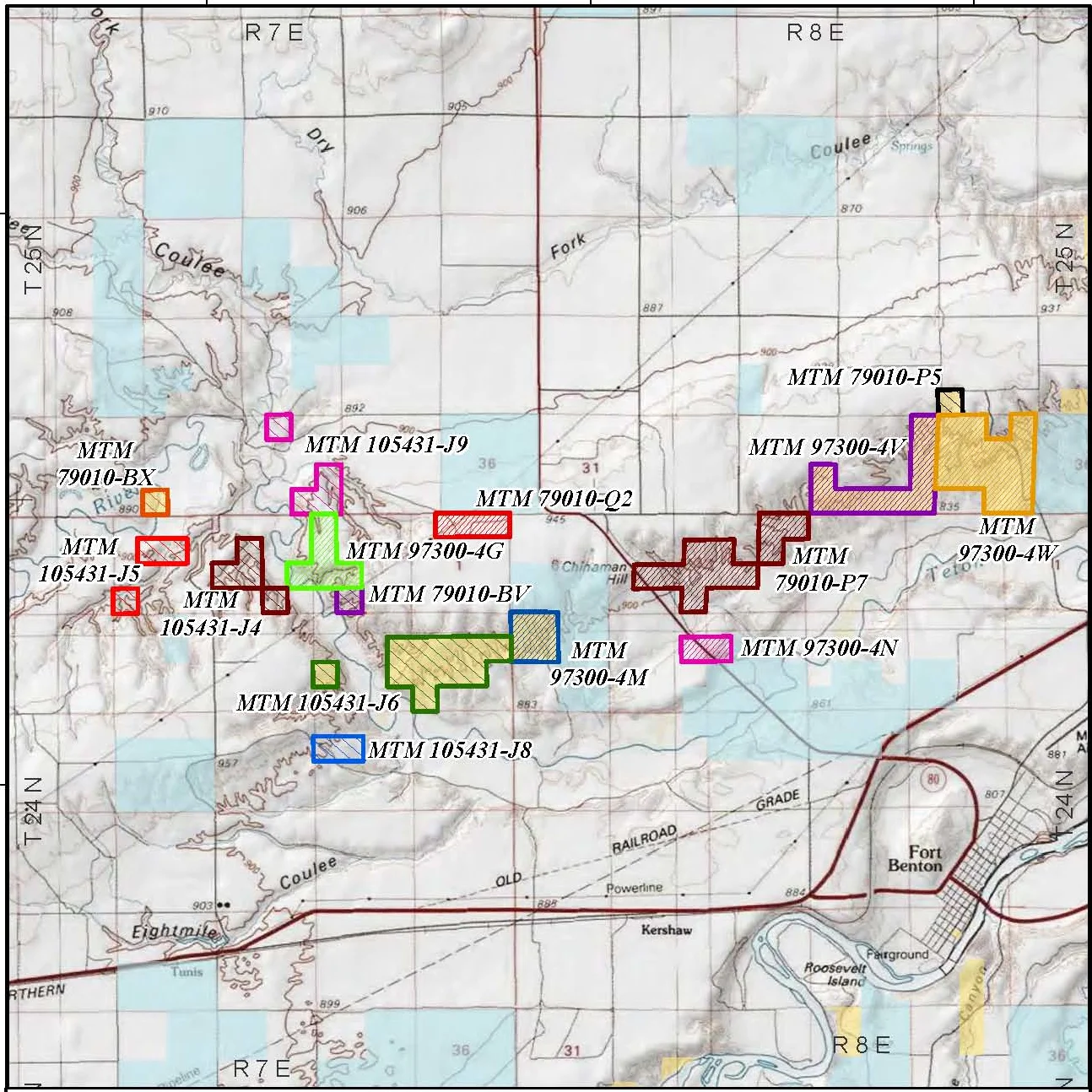
Most noticeable are the 10 parcels that sit right along the banks of the Milk River near Vandalia northwest of Glasgow. Then there’s the 15 parcels sitting chock-a-block along the Teton River north of Fort Benton and another bunch scattered through a remote prairie pothole region north of Malta between Loring and the Canadian border.
All of these are of concern to those who know that the fracking method of oil and gas drilling has the potential to pollute both surface and groundwater. The assessment itself points out that:
“Spills or produced fluids could potentially impact surface and ground water resources in the long term. Oil and gas exploration/development could contaminate aquifers with salts, drilling fluids, fluids and gases from other formations, detergents, solvents, hydrocarbons, metals, and nutrients… Groundwater removal could result in a depletion of flow in nearby streams and springs …”
Not only could oil and gas development affect the water but also wildlife will undoubtedly be disturbed. For example, the proposed parcels contain 1,320 acres of riparian and wetland habitat that could be degraded, taking a vast array of wildlife with it.
According to the environmental assessment, a few of the parcels near Havre are in the Kevin Rim Area of Critical Environmental Concern, home to known raptor nesting areas. The BLM is supposed to manage ACEC’s to protect and prevent irreparable damage to important historical, cultural, and scenic values, and fish and wildlife resources.
The breaks area along the Teton River north of Fort Benton Habitat provides nesting habitat for Neotropical birds and raptors and provides important winter range for mule deer.
In Valley County, many parcels are within 10 miles of the Milk River, which is mule deer and pronghorn antelope winter range. This area also provides habitat for all life cycles of sharp-tailed grouse, including; leks, breeding, nesting and brood-rearing.
Although the BLM eliminated 14 parcels that were in the sage grouse core area, a dozen parcels remain in what Montana has designated sage grouse connectivity habitat. If development occurred on these leases, no sage grouse would go near the area.
Finally, several of the Phillips County parcels contain prairie potholes and reservoirs that provide habitat for a variety of aquatic species such as the Northern Leopard Frog.
All of these could be threatened if the leases were bought and developed.
One lease has the double threat of not only being right beneath part of the Fresno Reservoir, which is part of the Milk River north of Havre, but also beneath private land.
It’s just one of the 52 leases that would lie beneath private land, not BLM land.
That’s one of the dangers of land in Montana – some land is actually a split estate where a private landowner has title to the land above but not the mineral rights below. So any oil company that buys the lease to those mineral rights can drill on someone’s land without needing their approval.
Some landowners manage to work out a financial agreement, but those who don’t want drilling may find it a contentious situation.
The BLM repeatedly says that creating leases in these areas does no harm – the harm might only arise when the lease is developed. So it can be difficult to summon enough justification to remove a parcel from consideration. BLM spokesmen say the agency does another study if the oil and gas company applies for a permit to drill. But by then, the process is one more step down the road and any challenge takes that much more effort. One only has to look at the struggle the Blackfoot have gone through to prevent drilling in the Badger-Two Medicine to see that it would have been better for the Blackfoot had the lease not been created and sold in the first place.
The public comment period on the EA runs until June 14. Send comments to BLM_MT_Great_Falls_Lease_EA@blm.gov . If approved, the sale of the parcels is slated to occur on Oct. 18.